

 |


| Quantity: | |
|---|---|
Product Description
1 System composition and work flow
1.1 System composition
The system can be divided into two parts: detection system and disposal system. The detection system is composed of radar, spectrum, photoelectric and other equipment, Carry out active and passive detection.
The disposal system is composed of jamming equipment, which is used to deal with the interference of radio signals and cut off the control link.The anti-ansys architecture is shown in Figure 1.
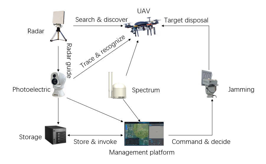
Figure 1. Antisystem Architecture
The working process of the anti-drone automatic system is as follows: firstly, the preliminary search and discovery of the target are realized through the radar detection equipment.
After determining the direction, distance, and speed of the target, the target signal is sent to the system.
Then, the electro-optical confirmation device receives the radar data, tracks and identifies the radar data, and generates visual and infrared images to assist threat determination.
At the same time, the spectrum detection equipment analyzes the communication signal of the target drone and identifies its control frequency band.Provide basic information for subsequent countermeasures.
The integrated display and control platform comprehensively displays the information of radar, photoelectric, spectrum detection and other equipment.Through the functions of data fusion, threat assessment, command distribution and remote monitoring, the operator can make command decisions.
After confirming the threat of drone, the system carries out counter-entrapment, as shown in fig. 2.
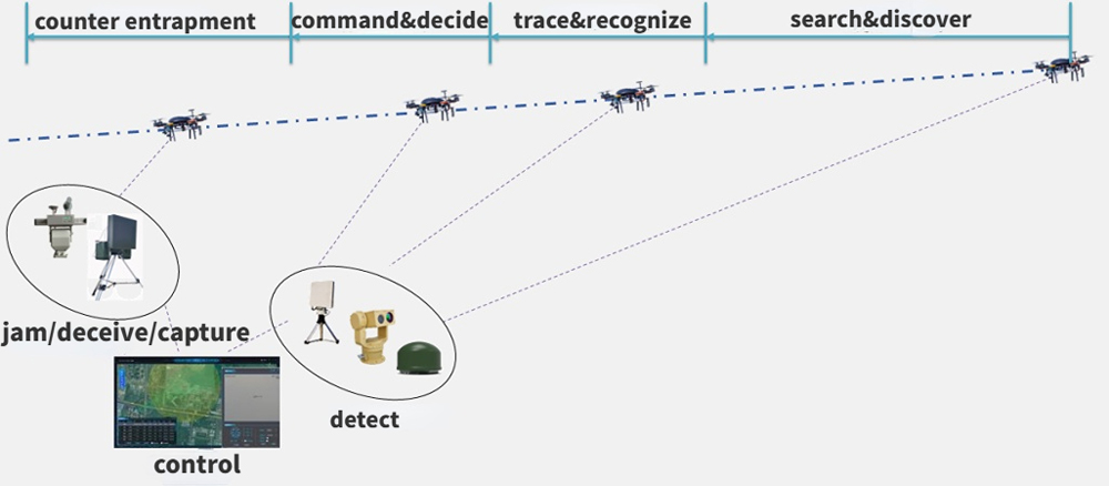
Figure 2 Work flow of anti-UAV system
1.2 Subsystem composition
1.2.1 Radar detection equipment
The three-coordinate surveillance radar developed by the company is selected as the radar detection equipment, and its appearance is shown in Figure 3. Mainly used for low-altitude and ground surveillance, the radar uses DBF technology. It has the characteristics of low equivalent omnidirectional radiation power and high search data rate. The radar uses adaptive clutter suppression and TBD techniques.The false alarm rate is very low, and it can automatically track more than 150 targets and output high-precision location information.
The main indicators are as follows:
(1) Radar band: X-band (10.4GHz ~ 10.6GHz);
(2) Detection range: ≥ 5 Km (typical target: DJI Spirit 4); ≥ 8 km (personnel); ≥ 10 km (vehicle)
(3) Refresh rate: 2S
(4) Target capacity: ≥ 200 batches;
(5) Close-range blind area: ≤ 50m
(6) Detection speed range: 1 ~ 150m/s
(7) Coverage: azimuth: 0 ° ~ 360 °; elevation: -5 ° ~ 30 °; maximum height: 1000 m
(8) Accuracy (root mean square): azimuth: ≤ 0.4 °; elevation: ≤ 0.4 °; distance: ≤ 5m;
(9) Antenna speed: 30 rpm (180 °/s)
(10) Communication protocol: UDP;
(11) Average power consumption of complete machine: ≤ 260W;
(12) Power: DC36~52V(supplied with AC220V-DC48V adapter);
(13) Working temperature: -40 ~ + 55 ℃
(14) Weight of complete machine (excluding triangular bracket): ≤ 30 kg.
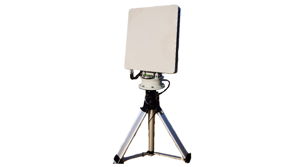
Figure 3 Appearance of Radar Detection Equipment
1.2.2 Photoelectric detection equipment
The appearance of the photoelectric detection device is shown in Figure 4.This type of photoelectric equipment is specially designed for airports, military bases, nuclear, biological and chemical bases, border and coastal defense, conference centers, office buildings and key places of prisons.The photoelectric detection and tracking integrated system is designed for low altitude safety.It adopts high-definition visible light camera and multi-spectrum detection module of non-refrigeration thermal imager, and cooperates with intelligent target detection and tracking module.It can effectively detect, track, identify and warn civil small and medium-sized consumer rotor and fixed-wing drones.
The main indicators are as follows:
Under the conditions of atmospheric visibility ≥ 20 km, humidity ≤ 50% RH and temperature difference > 6 K, for the target of 0.3m * 0.3m drone target
Visible light tracking distance ≥ 4000m, identification distance ≥ 3000m
Thermal image tracking distance ≥ 1500m, identification distance ≥ 1000m
Visible light:
(1) Resolution: 2688 * 1520
(2) Focal length: 12.5 ~ 7 75mm HD electric zoom lens
(3) Frame rate: 50hz
Thermal image:
(1) Detector: uncooled VOx infrared focal plane
(2) Resolution: 640 × 512
(3) NETD: better than 30mK
(4) Lens focal length: 230 mm continuous zoom lens
(5) Frame rate: 50hz
Servo:
(1) Rotation speed: horizontal 0.01 ° ~ 100 °/s, pitching 0.01 ° ~ 80 °/s; horizontal maximum speed ≥ 200 °/s
(2) Acceleration: 120 °/s ²
(3) Positioning accuracy: better than 0.005 °
(4) Tracking function: multiple tracking algorithms are built in.It supports multi-target detection, automatic capture, automatic zoom in the tracking process, real-time display of target trajectory, anti-temporary occlusion, etc.Manual and automatic tracking, supporting radar linkage
(5) Weight: ≤ 130 kg (reinforced base)
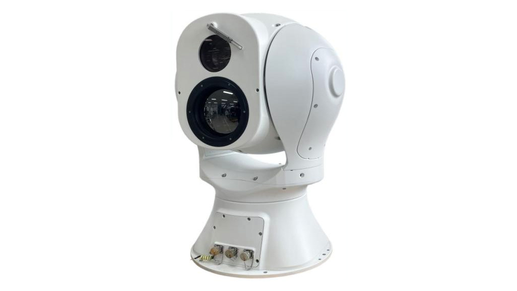
Figure 4 Appearance of photoelectric detection equipment
1.2.3 Spectrum detection equipment
The appearance of the detection device is shown in Figure 5.The device adopts cognitive radio protocol cracking (Cognitive Radio Protocol Cracking, CRPC) technology.It is a low-altitude security system to solve the detection, identification, positioning, defense and control of civil drones at home and abroad.The system can passively detect drones in protected areas, distinguish between the enemy and ourselves, and give the direction of drones.It can be used for low-altitude security defense in airports, prisons, important bases, stadiums and major events.
The main indicators are as follows:
1) Detection frequency band: 70MHz-6GHz full-band scanning, detection and display
2) FPV analog image transmission and detection: 500MHz-6GHz full-band scanning and display
3) FPV analog image transmission detection distance: ≥ 1.5km (support viewing real-time video)
4) Detection distance: ≥ 10 km (target drone Dajiang 2)
5) Detection range: horizontal detection angle up to 360 °, vertical detection range: -90 ° ~ 90 °
6) Detection response time: the time required from the time when the drone is powered on to the time when the equipment finds and reports the drone ≤ 10s
7) DF accuracy: ≤ ± 15 ° (RMS, under the condition of no obvious shelter and no obvious electromagnetic interference)
8) Detection display: drone distance, flight altitude, speed, position (including longitude and latitude,It is required to be accurate to 1 meter), aircraft model, aircraft SN, aircraft take-off point, aircraft return point, aircraft real-time trajectory, etc
9) Environmental adaptability: -40 ℃ ~ 60 ℃
10) Continuous working ability: able to work 24 hours a day
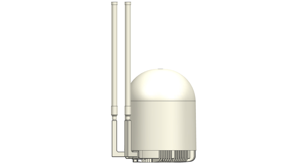
Figure 5 Appearance of spectrum detection equipment
1.2.4 Jamming equipment
The jamming equipment can strike the drone in normal flight accurately, and realize the directional expulsion of the UAV within the defense range.Its appearance is shown in Figure 6.The equipment can realize 24-hour all-weather protection in the laying area, can form an effective defense circle after laying, and has the advantages of quick effect,The effect is good, and the defense range can be adjusted according to the use requirements.
The main indicators are as follows:
1) Pressing distance: ≥ 2 km (depending on the working condition, the distance of different models is different.).
2) Suppression frequency:
band 1: 800MHz
Band 2: 900MHz
Band 3: 1.2GHz
Band 4: 1.4GHz
Band 5: 1.5GHz
Band 6: 2.4GHz
Band 7: 5.2GHz
Band 8: 5.8GHz
3) The power supply of the chassis is 220V, and the power consumption is about 800W (the transmission power of the RF module in each band is 30W-40W; 50 w for 2.4G and 5.8G)
4) Protection grade: IP66
5) Working temperature: -40 ℃ ~ 65 ℃
Figure 6 Appearance of Jamming Equipment
1.2.5 Anti-drone integrated management and control platform
The main interface of the anti-drone integrated management and control platform is shown in Figure 7.The platform integrates user management, video monitoring, target positioning, radar equipment management, spectrum equipment management, photoelectric equipment management. It is a comprehensive visual anti-drone system with control equipment.
The system combines video technology, intelligent detection technology, signal interference technology, network communication technology, in-depth learning technology and software platform technology, etc.Realize track display, video preview, status monitoring, electronic map, multi-level control, electronic fence, black and white list, information fusion,Intelligent analysis, alarm linkage, threat judgment, command and dispatch, equipment management, user management and data management.
It can carry out all-weather and multi-means automatic monitoring of UAV flight in the system defense area.It also reports the suspected targets in real time and accurately locates and tracks them, and adopts a multi-means comprehensive interception mode.Avoid the secondary damage caused by the interception of the unmanned aerial vehicle and realize the safe interception.It can meet the security needs of anti-drone in airports, national defense, frontier defense, prisons, large-scale activities and other scenarios.The main interface of the integrated management and control platform is shown in Figure 7.
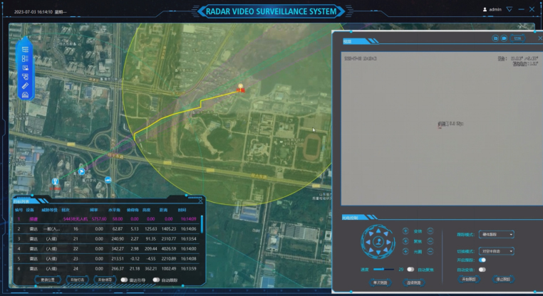
Figure 7 Main Interface of Integrated Management and Control Platform
The anti-drone protection system is based on advanced technology architecture.It focuses on the core functions of detection and perception, regional control, situation display, command and dispatch, unattended, anti-entrapment and system management.Build an all-weather, all-airspace three-dimensional protection system.The system is specially designed for the complex electromagnetic and airspace environment, and integrates radar, photoelectric, radio and other detection means.It combines intelligent research and judgment with linkage disposal mechanism.It can achieve accurate identification, rapid positioning and efficient disposal of UAV targets such as illegal intrusion and unreported flight.The system has the ability to work stably in the high-intensity operation environment.It can effectively support the protection of no-fly zones, the safety of flights taking off and landing, and the maintenance of airspace order.Improve the level of low-altitude security defense.
2.1 Detection and perception
It has the function of obtaining the surrounding wireless signal radiation and processing, analyzing and comparing the typical characteristic spectrum to determine the UAV model.
It has the functions of real-time monitoring of radiation sources, direction finding and tracking of suspicious targets.
It has the functions of omni-directional and all-weather target discovery, tracking, identification and monitoring.
It has the functions of real-time display, storage and playback of target images.
It has the function of image enhancement to enhance the ability of high-quality imaging surveillance in bad weather conditions.
With manual search, manual/automatic target tracking function;
Capable of information guidance, linkage monitoring and counteraction with radar detection, spectrum detection and jamming equipment.
Automatic zoom function according to radar target guidance information.
Moving target detection: The target detection algorithm based on space/time, frame correlation and neural network is used to realize the automatic detection of small and dim moving targets.
It has the function of real-time reporting of target angle, and realizes the output of information such as image, azimuth angle and pitch angle of the tracked target.
It has the functions of vehicle-mounted transportation and manual transportable erection.
It has the functions of self-inspection and status output of main modules of the equipment.
2.2 Regional control
Zoning control: supports the management of control areas based on circles, rectangles and polygons on the map.
Electronic fence: support adding multi-layer electronic fence and setting different alarm levels, such as "serious", "general", "warning", etc.
Map whitelist: support the addition of geographic whitelist to deduct the range of noise interference caused by different types of detection equipment on the map.
Aircraft whitelist: support the management function of whitelist for aircraft in specific frequency band.
2.3 Situation display
Map display: provide data map display in various modes such as vector map, image map and 3D map.Accurately display the security points and monitoring areas without deviation.
Deployment display: display the deployment information of detection equipment and interception equipment.
Target display: display the target track, indicate the action intention of the UAV, and plot the direction of travel.
Video preview: Obtain high-definition target image display through photoelectric equipment, and support visible light, infrared and tracking video display.
Alarm display: provide graphic display and voice alarm.
2.4 Command and dispatch
Linkage guidance: carry out comprehensive processing of radar and photoelectric heterogeneous sensor data to form a guidance command of the photoelectric turntable.Cooperate with photoelectric detection equipment to implement video linkage monitoring.
Action command and control: conduct threat judgment and assessment, select the optimal equipment for interception, and issue jamming instructions.Countermeasure and interfere with suspicious targets.
Information reporting: report the comprehensive detection information to the command and control center of the security field command.
2.5 Unattended
Unmanned operation, autonomous tracking, multi-source information fusion.
Unmanned operation, multi-target automatic guidance and autonomous tracking.
2.6 Counter entrapment
Jamming countermeasures: Under the guidance of command, it can jam the UAV target, cut off the link signal, and make the UAV land, drive away or return.
2.7 System management
Mission monitoring: monitor the status of UAV interception mission.
User management: multi-level management of users.
Equipment management: manage and maintain the equipment.
3.1 System characteristics
The system relies on its multi-dimensional perception ability, rich countermeasures and highly intelligent design.It can accurately detect, efficiently dispose of and comprehensively control potential threats in complex border environments.Relying on the deep artificial intelligence technology, the system not only realizes the all-weather and all-area monitoring capability,Moreover, through autonomous learning and optimization capabilities, it guarantees sustained technological advantages in future scenarios.Its characteristics of integration, modularization and safety ensure the stability and reliability of the system in long-term operation.It provides strong technical support for important facility safety, and its main features are as follows:
3.1.1 Multidimensional three-dimensional surveillance
The system integrates radar detection, photoelectric monitoring, spectrum detection and other multi-dimensional sensing technologies.An omni-directional three-dimensional monitoring network covering the air, ground and near-ground areas has been established.Whether it is the low-altitude invasion of small drones or the enemy agents sneaking into the ground, the system can accurately identify them in the first time.To achieve dynamic and real-time monitoring effect.
3.1.2 Enriching disposal means
The system has both hard strike and soft jamming means, and can be used according to different threat targets.Take a variety of countermeasures, including communication interference.At the same time of jamming, the system can also use photoelectric equipment to track and record in real time, and store the target behavior in the database.It provides an important basis for subsequent analysis. Diversified disposal means ensure the system's comprehensive response capability to emergencies.
3.1.3 Integration of management and control
The system operation platform seamlessly integrates data acquisition, situation analysis, target monitoring, threat disposal and other functions.Provide a clear and intuitive graphical interface.Users can view equipment deployment, target trajectory and regional early warning information in real time through two-dimensional/three-dimensional maps.At the same time, the system also supports the functions of electronic fence, zoning control and so on.It can delimit the early warning area on the map and set different levels of warning modes to achieve intelligent and accurate operation.
3.1.4 Deep artificial intelligence
The system introduces deep learning and neural network technology.It shows strong intelligent ability in target detection, behavior analysis, threat assessment and so on.Through the trajectory prediction algorithm, the system can predict potential threats in advance and take active intervention measures.In the process of target recognition, deep learning algorithm can achieve accurate extraction and classification of small and weak targets through large data training.Even under the condition of serious interference or complex environment, it can still ensure efficient identification.
3.1.5 All-day, all-time, all-dimensional
The system is designed for all-weather operations, day, night and extreme weather conditions.Provide reliable monitoring and protection functions.Its photoelectric module supports dual-mode switching between infrared and visible light, while radar can adapt to a variety of complex climates.It further enhances the all-weather detection capability.In addition, the system is excellent in terrain adaptability, whether it is jungle, mountain or desert.It can be deployed efficiently and operated stably for a long time.
3.1.6 Automatic collaboration and high efficiency
Each module of the system realizes a highly automated collaborative linkage.The radar can automatically guide the photoelectric equipment to lock the target and transmit the real-time detection information to the main control platform.The system can automatically assign disposal tasks according to the threat level.And complete a closed-loop process from target detection to disposal strike without manual intervention.The design of collaborative linkage significantly improves the efficiency of task response.
3.1.7 Flexible scale-out deployment
The system adopts the modular design concept, with high scalability and deployment flexibility.Its equipment unit supports various deployment modes such as vehicle-mounted, portable and fixed installation, and can be flexibly adjusted according to terrain characteristics and security needs.At the same time, the system reserves a variety of interfaces to facilitate interconnection with other security systems.To further enhance the overall security capability.
3.1.8 Safe, stable and reliable
The system is designed with military-grade hardware and distributed architecture to ensure the stability and anti-interference of core functions.The equipment has a perfect self-checking function, which can monitor the hardware status at any time during operation and output the results in real time.And is convenient for quickly troubleshoot.In addition, the system also uses multiple data encryption and communication protection measures to prevent external attacks and ensure information security.
3.2 System advantage
In the design process, the system fully combines the actual needs of the complex environment.It integrates advanced artificial intelligence, large data analysis and automation control technology to achieve high-precision detection and efficient disposal.Pay attention to the simplicity of operation and the overall security of the system.Through the design of integrated platform and modular architecture, the system can not only deal with the current diversified threats, but also solve the current problems.It also has high expansibility and foresight, which provides a solid foundation for the upgrade and optimization of security system in the future.The main advantages are as follows.
3.2.1 Software platform integration
Through the integrated platform design, the system integrates detection, early warning, counter-control, display, management and other multi-functional modules into one.Users can complete the whole process operation in a single interface.The platform supports the integrated management of multiple devices and multiple signal sources, effectively avoiding the problems of device dispersion and information islands in the traditional system.The overall efficiency and operation experience have been greatly improved.
3.2.2 High detection stability and precision
The system uses high-performance detection equipment, with enhanced algorithms and signal processing technology, can accurately locate and track targets in real time.And provide high resolution imaging results.Especially in complex terrain and harsh weather conditions, the system can still maintain high-precision detection capability.Effectively reduce the possibility of false positives and false negatives.
3.2.3 AI Enabling More Intelligence
Driven by artificial intelligence technology, the system shows remarkable intelligence in target recognition, behavior judgment and threat assessment.Through in-depth learning technology, the system can adaptively adjust parameters according to environmental changes.Achieve more efficient detection and more accurate strike effect.In addition, the self-learning ability of the system also supports the continuous optimization of the algorithm to deal with more potential threats in the future.
3.2.4 All-weather and all-region adaptability
For extreme environments such as high temperature, high humidity, low temperature and strong wind, the system adopts specially designed protective measures.Ensure the long-term stable operation of the equipment.At the same time, whether it is fixed deployment or rapid mobility, the system can adapt efficiently and provide support for security protection in various scenarios.
3.2.5 Modular design and flexible expansion
The modular design of the system not only supports multiple deployment modes, but also facilitates function upgrade and performance optimization in the later period.Users can quickly add or adjust modules according to actual needs.For example, adding more accurate sensors, improving the performance of anti-control equipment, and so on, to ensure that the system always maintains the leading technology.
3.2.6 Data security and stability assurance
The system ensures that sensitive information is not leaked during transmission through two-way encrypted communication and multi-layer protection architecture.In addition, the core module has high reliability design and redundant backup capability, even if the key equipment is damaged.The system can also continue to complete the task through other ways to ensure the integrity and stability of the protection link.


